|
||||||||||||||||||||
|
The Laois/Offaly Dail constituency, which combines the Counties of Laois and Offaly for general election purposes, has been a single five seat constituency since 1923 and its two counties are the only two to have remained together since that date without any major revisions having taken place. Social and Cultural Information:
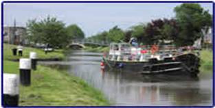
County Offaly-The Faithful(Contae Uíbh Fhailí): Originally the Kingdom (Clan) of Uí Failghe, it’s modern boundaries were first formally drawn in 1556 by Mary I of England during the Plantations of Ireland, it was originally named King's County, after King Phillip II of Spain and the county town was Daingean (Philliptown) until 1835. From 1835 onward Tullamore became the county town and as remained the main population, commercial and administrative centre in Offaly since. Geographical Offaly is very rich in the southern part of the county is occupied by the Slieve Bloom Mountains, the north-western part is the floodplain of the River Shannon and the remainder consists of large bogs including the Bog of Allen and Boora Bog. Tullamore (Tulach Mhór) was part of the first English plantation of Offaly in the 1570s. While only a small village at the beginning of the 18th century. It started to grow following the placement of large cavalry unit in the town in 1716. This increased trade and employment increased in the village and in surrounding rural areas. Another major factor was the inheritance of the Charville estate on which the village was located in 1765 by Charles William Bury. Bury’s progressive views and financial investment promoted the growth of the town. In 1785 the town was seriously damaged when the crash of a hot air balloon resulted in a fire that burned down about 100 houses giving the town the unusual distinction of being home to the world's first aviation disaster. This incident provided an opportunity to develop the town and the arrival of Grand Canal which linked Tullamore to Dublin in 1798 lead to a major development of the town in commercial terms.
The towns most famous export is Tullamore Dew - an Irish whiskey previously distilled by Tullamore Distillery - that can be traced back to 1829. The distillery closed in the 1950s but its traces are still visible in the town. In recent times the distillery buildings have been converted to use as museum and tourism centre. Today the town as population of approximately 20,000 (2002) and is a major commercial and industrial centre in the midlands region and is renowned for its medical industry. Major international employers in the town include 'Tyco Healthcare' and 'Boston Scientific'. Tullamore is also the location of the 'Midland Regional Hospital' and 'Midland Health Services Executive' which employ over 1000 people. A new state of the art hospital is currently under construction and due to open in 2007. The Department of Education buildings section is also located in the town. In 2003, Tullamore was designated a 'gateway' town under government development plans for the country. This made the town eligible for increased infrastructural investment which is set to develop road, rail and broadband provision in the area, as well as develop the town and its surrounding area. In recent times the town as developed the Tullamore Show which as become a landmark annual event in for the agricultural and business community in Ireland and as gained both national and international renowned. The town received a bronze medal in the National Tidy Towns Competition in 2004 and also played host the 'World Sheep Dog Trials' in 2005 which attracted huge international interest in the region.
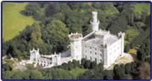
Tullamore as enjoyed increased levels of tourism and continues to offer new events and places of interest to tourists including Charville Castle, the Grand Canal, the Tullamore Dew Heritage Centre and Tullamore Jail. The town as also developed a number of events which have developed the regions appeal to tourist including: the Phoenix festival and Mor festival. Information on Towns in Offaly will be uploaded shortly
County Laois (Contae Laoise): Was founded in 1556 by Mary I of England as Queen's County, Laois received its present Irish language name following the War of Irish Independence. Portlaoise (previously Maryborough) is the county town. Laois was the subject of two Plantations or colonisations by English settlers. The first occurred in 1556, when the Earl of Sussex dispossessed the O'Moore clan from the area and attempted to replace them with English settlers. However, this only led to a long drawn out guerrilla war in the county and left a small English community clustered around garrisons. There was a more successful plantation in the county in 17th century, which expanded the existing English settlement with more landowners and tenants from England. Finally, the county became home to a community of French Huguenots in the 1690s, who were settled in Ireland after their service to William of Orange in the Williamite war in Ireland. In addition to this, large numbers of Quakers settled in Mountmellick and developed the area. Agriculture is the largest sector of the economy, with 70 % of the area (1,200 km²), farmed every year. The county is home to over 230,000 cattle, that is four cows for every person. The county has a small industrial base, with industrial parks at Portlaoise and Mountmellick. Over 1500 people work in the industrial sector in County Laois. However, unemployment is higher than other Irish counties in County Laois and annual income is lower than the national average, at about 88% of the average. The county makes up part of the Border Midlands and West region for the purposes of EU funding. Portlaoise (older spelling Portlaoighise), is the county town of County Laois. The name is Irish for "Fort of Laois", however, a partially anglicised pronunciation as "Port Laois" is common, although the inland town is not a port. The population in 2002 was 12,127. The town was first established by Queen Mary in 1556 as "the Fort of Maryborough" and was renamed through a public competition in1922 to "Portlaoise". Signs of the old garrison remain all over the town, and the old jail has been transformed into an arts centre. Nearby is the Rock of Dunamase, an ancient Celtic fortification, allegedly recorded by Ptolemy in the 1st century. Also nearby are Emo Court, an 18th-century country house designed by James Gandon; Ballyfin House, now a private school; and Mountmellick, the site of a notable Georgian square. The town is a major commercial, retail, and arts centre for the midlands. It is home to Ireland's maximum-security Portlaoise Jail, which houses the majority of paramilitary prisoners sentenced in the Republic, and to the Midlands Prison. Both establishments are major employers in the town. There are also several hundred employed in the Department of Agriculture in the town. This is expected to increase further under the governments planned decentralisation of government departments from Dublin. The town also has a large and growing commuter population availing of the rail and motorway connections to Dublin. The National Spatial Strategy for Ireland has identified Portlaoise as an ideal location for an inland commuter port. This designation encourages the town to focus on the growth of distribution, logistics and warehouse uses, which ties in well with its strong transport connections. Portlaoise stands at a major crossroads in the Irish roads network although construction in recent years of the M7 motorway, which bypasses the town, has reduced traffic congestion in the town centre. The town has a railway station served by intercity trains between Dublin and Cork and by Dublin commuter services. Significant nearby local tourist sites, include the ruins of an 800 year old hill-top castle at Dunamaise, a large Georgian estate home and surrounding guardians at Emo, and the Slieve Bloom Mountains & Forest Park. Information on Towns in Laois will be uploaded shortly Political Information This Section is underconstruction
|
|||||||||||||||||||
| Copyright © 2004, Adam Particka. All Rights Reserved. | ||||||||||||||||||||
 Laois/Offaly